The Volcanic History of Taranaki
This booklet should be referred to as:- V.E. Neall 1974. 'The Volcanic History of Taranaki'. Published by Egmont National Park Board.
Taranaki Maunga knowen as Mount Egmont and the ranges extending towards New
Plymouth have been built by volcanic activity that has lasted
from early Pleistocene times (about 2 million years ago) almost
to the present day (see Table 1). Prior to this Taranaki was
covered by a shallow sea, (e.g., seashell deposits of eastern
Taranaki) beneath which a sequence of sediments was being
deposited during the Tertiary period (mainly between 12 and
60 million years ago). Oil and gas within these sediments have
flowed into structures which have been subsequently drilled and
commercially developed e.g. at Kapuni. The lavas which have
been extruded from Mt Egmont and the other volcanoes cover
a comparatively small area at high altitudes, and below the
900 m contour they merge into a thick apron of fragmentary
volcanic debris called the ringplain. Because the latest activity
on each volcano destroyed the previous deposits near their
source, a complete geological history of the area involves
investigations both within and outside the National Park. The
outskirts of the Taranaki volcanic ringplains are bounded to the
west by the coast and to the east by uplifted Tertiary mudstone
country from Urenui south to Hawera.
With time the activity has followed a NNW to SSE trend
in Taranaki along an apparent major linear fracture in the
earth's crust. Progressing southwards along this fracture each
volcano is seen to be associated with a progressively more recent
and youthful landscape. From north to south are: (see map, p3)
1. Paritutu and the Sugar Loaves at New Plymouth,
positioned slightly to the north-east of the principal
volcanic line.
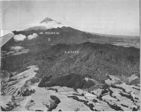
2. Kaitake, a disembowelled extinct volcano.
3. Pouakai, a severely eroded and extinct volcano, and
4. Egmo nt, a classic volcanic cone of interbedded lavas
and breccias (coarse angular rock fragments set in a matrix).
