PG:4
POUAKAI
Ten kilometres to the south-east of the Kaitake Range
is the Pouakai Range, an extensive mountainous area rising to
1,377 m, with a diameter of between a half and two thirds that
of Egmont. About ┬ą.! million years ago an extensive ringplain of
volcanic breccias was formed around Pouakai volcano by huge
volcanic mudflows (now called by the Indonesian term lahars)
which descended from the upper Pouakai slopes prising underlying sediments into "rafts". Along the coast north of Oakura,
30 ft (9 m) "rafts" of fossiliferous mudstones may be found
within the volcanic breccias.
About this time most of the Pouakai tephras were
erupted covering the landscape with a mantle of volcanic ash,
upon the fertile soils of which the productive dairy industry in
the Okato and Inglewood regions now depends. Here the landscape comprises gently seaward-dipping interfluves (surfaces
between streams) with steep sided valleys entrenched through
the ashes and onto the bedrock.
The southern Pouakai ringplain has been eroded by more
recent lahars from Egmont and in addition the upper parts of
the original volcano have been eroded by stream and ice action
so that only the lower and middle portions remain. In fact
during the last period of climatic cooling, 15 -20,000 years ago,
(the Last Glaciation) many of the tephras covering the upper
slopes of the Pouakai Range were eroded and redeposited as
dunes and mounds at lower altitudes. These deposits are clearly
visible along Carrington Road.<br.
Rocks within the Pouakai Range are mostly columnar
jointed andesite flows and some diorites. Within the lava rock
one may sometimes find radiating aggregates of hornblende
crystals and also foreign rocks (called xenoliths) of diorites,
schists (highly altered rocks which have suffered high temperatures and/or pressures) and sediments which became incorporated in the lavas as they broke through to the surface.
Representative samples of these rocks together with those from
Egmont can be easily collected in the beds of Stony and
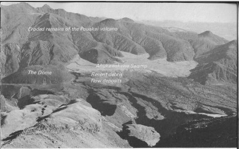
Waiwakaiho Rivers. The large Ahukawakawa Swamp between
Egmont and Pouakai was regarded as a caldera (a depression
generally due to subsidence of a volcano's core region) by
Gibson and Morgan (1927) but there is little evidence of any
circular faulting to substantiate a collapse caldera origin.