PG:5
Taranaki Maunga / Egmont
Little is known of when activity commenced at the Egmont centre but some of the oldest deposits are exposed in the coastal Cliffs of southern Taranaki, particularly between Manaia and Hawera. Early tephras preserved in the Okato-Oakura region suggest activity at the Egmont centre began 50-70,000 years ago. It appears that a substantial cone had been constructed by 35,000 years ago and that about this time an eruption occurred leading to large scale collapse. The bulk of the cone slid westwards as a huge lahar to beyond the present coastline. Collapses of this type appear to have been a repetitive and common occurrence with the Taranaki volcanoes and much controversy exists as to their cause. Grant-Taylor (1970) has proposed that these eruptions occurred during glacial periods when eruptions pierced large accumulations of ice which rapidly melted and transported vast quantities of volcanic detritus seawards. However, more detailed studies show that some lahars have originated from Egmont during periods of warmer climate too, and it is possible these originated from collapse of a crater lake. To the non-geologist such events are difficult to visualize but similar collapses have been recorded in historical times in Iceland, Kamchatka (Russia), and in Indonesia where lahars have travelled up to 90 kilometres from their source. The 1953 Tangiwai Disaster here in New Zealand was caused by a small lahar generated by partial collapse of Mt Ruapehu's crater lake. Water charged with rock debris swept down the Whangaehu River and washed away a railway bridge as the main express was crossing it, killing 151 people.
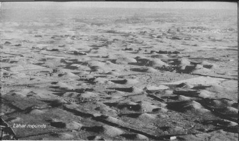
The huge lahar deposits in western Taranaki (see map
p.15) stretch southward from Okato to near Te Kiri and are
typical of lahar deposits throughout the world. In particular they show many thousands of various sized mounds
developed on their upper surface. Within most of the mounds
is an unsorted, chaotic arrangement of andesite lava fragments
with little or no bedding. Elsewhere on Egmont ring plain where
mounds are absent the lahars progressed as a surge of debris
charged with water in the manner of a flood.
About 20,000 years ago, whilst a new cone was being
constructed at the Egmont centre, magma (molten rock under a
volcano) also burst to the surface to form Pukeiti cone. The lava
flows extruded at this time include that at Dawson Falls and
the remnants at Warwicks and Humphries Castles. Fanthams
Peak is also known to have existed at this time because it
deflected later lahars to the south-west and has protected a strip
of older ringplain between Auroa and Mangawhero Roads near
Awatuna. From 16,000 years ago the remainder of the present
upper cone was built accompanied by frequent collapses of
unstable materials to the west and eruption of volcanic ashes
that now form the topsoil over much of Taranaki (the Oakura
and Okato tephras and the Stratford Shower). At least two
lahars have reached the present coastline since then and the
younger one, dated at 7,000 years old, was clearly derived from
the large "amphitheatre" which now exists between Bobs Ridge
and Fanthams Peak.