PG:3
PARITUTU AND THE SUGAR LOAVES
The earliest evidence of a volcano preserved onshore in
the Taranaki district is at Paritutu. Early geologists regarded
these volcanic remnants as an old volcano denuded by the sea
(Hutton 1944), but more recent work by Arnold (1959) suggests
they represent a growing volcano which became pierced by a
series of highly viscous, craterless lava domes (cumulodomes).
Numerous small crystals (called phenocrysts) in the lavas are
aligned in circular or curved patterns around most of the Sugar
Loaves confirming this origin.
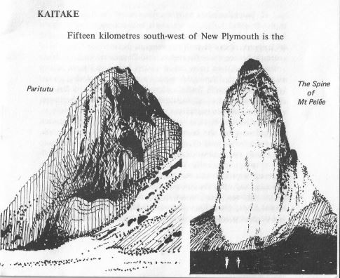
Paritutu is thought to represent a plug or spine of lava
that was extruded in nearly solid form, like a piston, in much
the same way as a famous spine was thrust up from the summit
of Mt Pelee on the Caribbean island of Martinique in 1902 A.D.
A zone of crushed rock around the base of Paritutu probably
marks the circular fault up which the spine was extruded. The rocks have been radiometrically dated at about I * million
years old (Dr I.J. Stipp, personal communication). This dating
is determined from the amount of time that has elapsed since
the rock solidified, by measuring the stage of decomposition of
certain radioactive elements e.g, potassium which decomposes
to argon. This decomposition proceeds at a known rate and
when particular element contents of a rock are analysed and
compared to these rates the age is easily computed. It is probably
due to these volcanic extrusions fracturing the underlying
sediments that oil has seeped upwards along small fissures to
form oil seeps and gas vents on the New Plymouth foreshore.
For about 65 years oil has flowed in small quantities from this
field, yielding some 4,500,000 litres of crude oil and 100000 , m"
of natural gas per year.
KAITAKE
Fifteen kilometres south-west of New Plymouth is the Kaitake Range where volcanic activity began about Y2 million years ago (Stipp, pers. com.). Advanced erosion has reduced the volcano to a circular area of radiating ridges which rise to the central point Patuha 673 m in altitude. There is little evidence preserved today of the activity associated with this volcano because most of the rock outcrops are covered in bush. Of the few rocks exposed, most are andesites and diorites. These have become altered by percolating hot solutions to quartz and kaolinite (china clay) with small quantities of pyrite. Gold, silver and copper have been reported from the Boars Head mine on the north-west side of the Range, but the workings were quickly abandoned.